
避免在山上迷途,是每一位登山健行者必備的認知,學習看離線地圖無疑是一個降低迷途風險的好方法。
看地圖好像是件很難的事?多少有些人會產生抗拒感,但如果你在山上也會看登山布條認路的話,其實只要想像成「看離線地圖 = 把看布條認路這件事移師到手機上。」 會不會覺得友善一些呢?
此篇文章提供基本的離線地圖使用教學,學成就能大大降低在山上迷途的風險哦。
Q. 為何使用離線地圖
上山時常會遇到手機訊號不佳或完全無收訊之情況,此時需網路連線的線上地圖是無法使用的(例:Google Maps)。因此在山下預先下載離線地圖,是為了在無網路收訊的情況下,也能依據離線地圖來判別自身位置。
Q. 離線地圖的方向辨識原理
要使用離線地圖,需運用智慧型手機,搭配預先載好的離線地圖。一般智慧型手機都擁有GPS(全球衛星定位系統),可利用衛星訊號來判別你在地表上的位置。GPS定位不需網路訊號、也無需手機訊號就能使用。只要在山上開啟預先載好的離線地圖,依靠手機GPS定位,你當下的位置即會顯示在地圖上,就能確認行進時有無偏離路徑。
◼️ 離線地圖 使用教學
這裡以APP【HikingBook】作範例教學 ( APP可免費下載 )
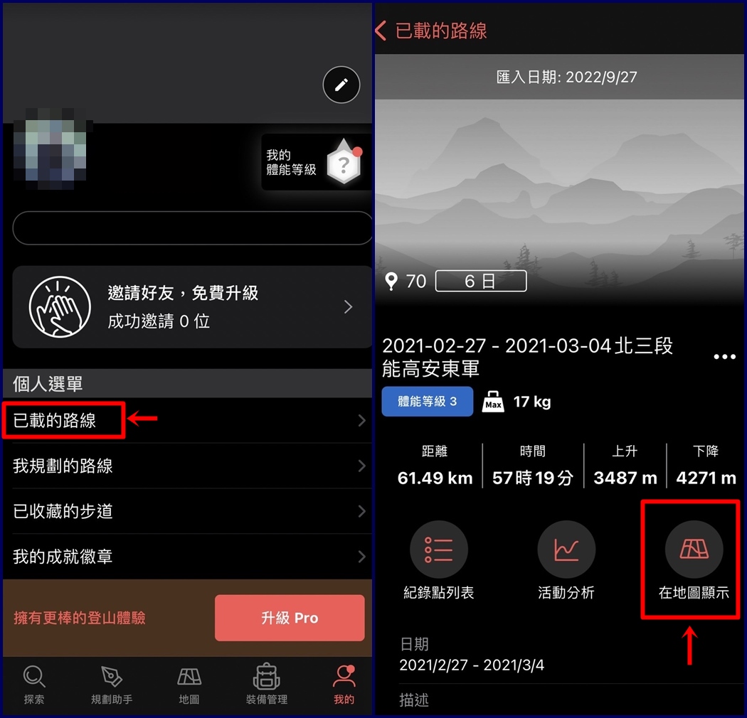
開啟APP後,點選 [探索] 於搜尋欄位輸入要找的路線名稱 (ex.能高安東軍)
可從 [官方路線] 或 [登山活動] 選擇要下載的離線地圖。
PS. [登山活動] 是其他山友上傳的GPX軌跡檔案,走的路線不盡相同,可自行選擇適合的圖資。

下載完成後從 [我的] > [已載的路線],可看到下載好的離線地圖,點進去後再點選 [在地圖顯示],離線地圖即會出現。
在山上打開離線地圖,會發現你自身的位置就是地圖上的藍色箭頭,可藉此判斷行進時有無偏離路徑。

◼️ 一些小撇步
* 剛打開地圖時,GPS可能會有誤差情況(定位會飄移),等待約5~10秒讓GPS訊號穩定後,再來確認位置。
* 關閉網路藍芽、開啟飛航模式,可節省手機電量。
以上介紹離線地圖最基本的方向辨識功能,學成後至少能讓自己在山上多一份預防迷途的保障。
網路上可找到許多關於離線地圖更詳盡的功能及教學資訊,也建議大家多加學習利用囉!


